
The South Caucasus, located between the Black and Caspian Seas on one side and the Caucasus Mountains and Iranian Plateau on the other, is a land bridge that can connect regions lying east or west and north or south of the region.
Communications (transport and energy) in the first direction gained particular importance after the collapse of the USSR. The concept of communications in this direction is the so-called Middle Corridor or trans-Caspian route, which is the shortest and fastest land route from China to Europe.
North-south communications mainly ensured the region’s connection with the metropolis (Moscow). After Russia’s 2022 aggression against Ukraine, the region’s communications gained new importance – on the one hand ensuring the flow of goods from China to Europe, on the other hand, Russia, facing sanctions imposed by Western countries and their allies, began searching for new routes to the growing markets of South Asia. Since that period, Russia’s efforts to establish a direct railway connection with Iran have intensified, and the construction of the Astara-Rasht (165 km) railway was financed.
Under the conditions of the Artsakh conflict, east-west operating communications in the South Caucasus only pass through the territories of Georgia and Azerbaijan.
Due to the South Ossetian and Abkhazian conflicts, two of the four main routes leading south from the North Caucasus are closed – the one through Abkhazia and the Central Caucasus (TransKAM), the latter being more comfortable than the strategic road.
The only fully functional route in this direction is the railway and highway along the Caspian Sea coast (Russia-Azerbaijan). Along this line, Russia, Azerbaijan, and Iran have intensified work since 2022, particularly focused on constructing the Astara-Rasht railway, which will create a direct land connection between the railway networks of Russia, Iran, and South Asia.
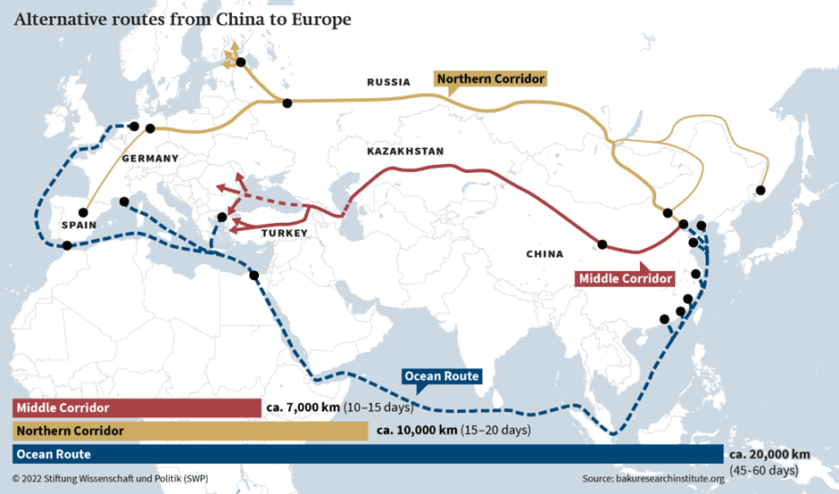
Map 1. Main China-Europe transport routes and their cargo transportation duration[i]
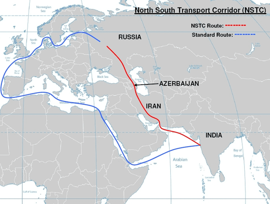
Map 2. North-South Transport Corridor[ii]
“Zangezur Corridor”
Azerbaijan has proposed the “Zangezur Corridor” route for the East-West connection, which envisions connecting Azerbaijan’s main territory with the Nakhichevan Autonomous Republic and Turkey via a railway running along the Araks River in Armenia’s Syunik region. This railway’s construction was completed in 1941. It was a continuation of the Yerevan-Julfa railway built in 1908 towards Baku. During the Soviet years, this route was under Azerbaijani railway management since it passed through only a short section (44 km) within Armenia and had no separate significance. For the same reason, the Ijevan-Aghstafa railway, which until the late 1980s didn’t go deep into the Armenian SSR territory, was also under Azerbaijani railway management. This argument is still used in Azerbaijani discourse to justify privileged passage to Nakhichevan. The total length of the road (including the Meghri section) is about 625 km. After the completion of the Kars-Nakhichevan (224 km) railway being built by Turkey (planned for 2028-2029), the Kars-Nakhichevan-Baku route will be about 850 km, which is almost the same as the Baku-Tbilisi-Kars railway (841 km). However, the latter passes through more mountainous terrain, especially in the Tsalka-Akhalkalaki-Ardahan section, and has limited capacity. This is mainly due to the slopes in mountainous areas. According to Azerbaijani and Turkish statements, the “Zangezur Corridor” route should connect these countries with Central Asia, serving as part of the Middle Corridor or Trans-Caspian route. The first operational route of the Middle Corridor since 2017 has been the Kars-Tbilisi-Baku railway (841 km), through which cargo transportation from China also intensified after the start of the Russian-Ukrainian war in 2022. Under conditions of growing demand, this road’s capacity is severely limited due to its mountainous sections.
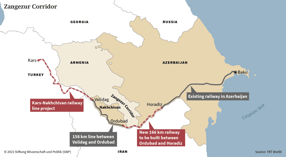
Map 3. The Kars-Nakhichevan-Baku Railway or “Zangezur Corridor” Project[iii]
The route of the “Zangezur Corridor” has both advantages compared to the Kars-Tbilisi-Baku railway (related to the lower slope of the terrain) and disadvantages. About half of the route – a 400 km section – runs just a few kilometers from the Iranian border (and in some sections, less than 1 km). Under conditions of military-political instability, it is highly vulnerable.
From Armenia’s interests perspective, it is also problematic as it minimizes Armenia’s potential profits and participation in international transit trade.
“The Crossroad of Peace”
This Armenian project was presented at the Silk Road Forum IV in Tbilisi on October 26, 2023. Instead of focusing on a single corridor-based route, it encompasses the use of all existing and restorable communications with all neighboring countries while maintaining sovereignty principles. This includes both road and railway routes. The same principle is intended for energy and any other communications. This approach also allows bypassing the low throughput issues of individual routes and managing flows through the most optimal paths at any given time.
According to this project, the Iran-Armenia-Georgia connection, which can be part of both North-South and East-West communications, is implemented through the “North-South” highway under construction. Azerbaijan gets the opportunity to use Armenia’s existing and repairable routes (Meghri railway – 44 km, Azatamut-Ijevan-Meghradzor railway – about 67 km). Through these, it establishes connection with the Nakhichevan Autonomous Republic, including via automobile routes through Syunik and Gegharkunik regions, and gains access to Turkey using the Baku-Meghri-Nakhichevan-Sadarak-Yerevan-Gyumri-Kars, Baku-Tbilisi-Ayrum-Vanadzor-Gyumri-Kars routes, and if the Azatamut-Meghradzor railway is restored, the Baku-Agstafa-Ijevan-Yerevan-Gyumri-Kars routes.
By entering Armenian territory through several checkpoints via automobile routes (Sotk, Azatamut, Yeraskh), it is possible to reach Turkey through the Margara and Akhurik checkpoints. Thus, instead of one route or “corridor,” various routes are proposed, both railway and automobile.
The Armenian proposal theoretically allows the use of all existing and future communications in all possible directions (East-West, North-South).
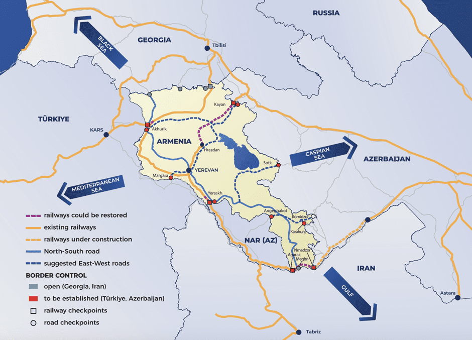
Map 4. “The Crossroad of Peace” Project[iv]
Nevertheless, this proposal regarding routes has several important shortcomings.
First, while the Azerbaijani and Turkish sides have built new routes (Kars-Tbilisi-Baku) or plan to build them (Kars-Nakhichevan, restoration of the Horadiz-Armenia border section by 2025), the Armenian proposal is based on restoring communications that existed during the Soviet period.
One of the important shortcomings is the issue of the Vanadzor-Fioletovo railway, which could shorten the Tbilisi-Yerevan route by 112 km and, with the restoration of the Azatamut-Ijevan-Fioletovo section, become the shortest railway route of the Middle Corridor in the South Caucasus. According to my calculations, the length of the Baku-Agstafa-Ijevan-Fioletovo-Vanadzor-Gyumri-Kars railway is 710 km, which is about 140 km shorter than the planned Kars-Nakhichevan-Baku route and 130 km shorter than the Kars-Tbilisi-Baku route, while also passing through more favorable topographic terrain compared to the latter. Being distant from both Russian and Iranian borders, this is also the safest route for the Middle Corridor in case of possible political instability in the North Caucasus and Iran.
Currently, this line needs restoration of approximately 16.2 km section in Azerbaijan’s territory (of which 13.5 km is Gazakh station – Armenian border, 2.7 km section in the Sofulu-Barkhudarlu exclave), about 66.8 km section from the Azerbaijan border to Fioletovo in Armenia’s territory. The Fioletovo-Vanadzor section, approximately 26-32 km in length (depending on the specific project), which was planned since 2012, needs to be completely new.
In the future, with the opening of the Abkhazian route and Trans-Kam, Armenia’s territory would also become the most convenient and shortest route from western and central Caucasus and Georgia to Iran and South Asia, which would allow Armenia to become an important transport hub.
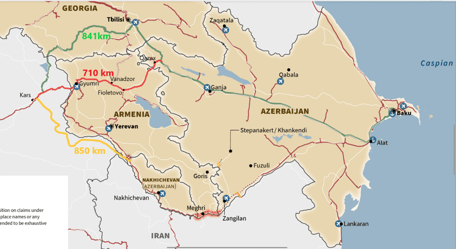
Map 5. The Proposed Kars-Vanadzor-Ijevan-Gazakh-Baku Railway Compared to Competing Routes
Another significant shortcoming of the Armenian proposals is that while the Azerbaijani and Turkish sides have immediately moved to practical work, the Armenian side has not yet started any work towards restoring the destroyed routes (Ijevan, Meghri). The North-South highway, which is also a crucial element of the presented project, will only near completion during the next decade. Furthermore, in case of unblocking the railway through the Nakhichevan Autonomous Region, it will significantly lose its importance.
Conclusion
Although Armenia’s proposed “The Crossroad of Peace” project is theoretically more beneficial, no practical work has been done yet to restore the routes mentioned in the program. It also ignores important and more optimal routes that could make the communications passing through Armenia’s territory the shortest and safest section of the Middle Corridor.
[i] https://www.swp-berlin.org/10.18449/2022C64/
[ii]https://upload.wikimedia.org/wikipedia/commons/3/37/North_South_Transport_Corridor_%28NSTC%29.jpg
[iii] https://www.swp-berlin.org/10.18449/2022C64/
[iv] https://upload.wikimedia.org/wikipedia/commons/d/d8/Crossroad_of_Peace.png
Author: RCSP associate expert Samvel Meliksetyan
