
The existence of a roughly 17-kilometer-long shared border between Azerbaijan and Turkey, located in the northwestern part of the Nakhchivan Autonomous Republic, has given rise to numerous conflicting theories, including within academic circles. Since the late 1980s, a hypothesis has gained traction in Armenian historiography and expert discussions, suggesting that this border was established in the 1930s as a result of Turkish-Iranian territorial exchanges and border demarcation. This article thoroughly refutes that hypothesis.
The Section of Turkey Bordering Nakhchivan During the Russian Empire
The intersection of the modern borders of the Republic of Armenia, Azerbaijan, Turkey, and Iran was shaped in the early 19th century, when the territorial conquests of the Russian Empire were formalized through the Treaty of Turkmenchay in 1828. Following this treaty, the khanates of Erivan and Nakhchivan were reorganized into the Armenian Oblast, which later (in 1849) became the Erivan Governorate. A small portion of the former Erivan Khanate, located south of the Ararat massif, remained under Persian control. However, a narrow strip of land between the rivers Karasu (Karakasu) and Aras was ceded to the Russian Empire.
This section, now part of Turkey’s Iğdır Province and bordering the Nakhchivan Autonomous Republic, was, during the Tsarist era, paradoxically not included in the Surmalu Uyezd—the only trans-Aras district of the Erivan Governorate corresponding to modern-day Iğdır Province. Instead, it was part of the Erivan Uyezd of the Erivan Governorate, specifically the fourth police precinct (полицейский участок), comprising two rural communities: Gejimkanli and Kirmizikanli.
By 1873, Kurdish settlements in this area were still listed as winter pastures (зимовники). According to village registers of the Erivan Governorate and the Russian military’s five-verst map, this narrow strip of land hosted 11 villages populated by Muslims—10 Kurdish and 1 Turkic (Azerbaijani), the latter being Sarukhanlu.
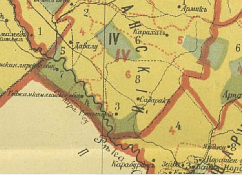
Map 1: E. Kondratenko’s Ethnic Map of the Trans-Aras Section of the Erivan Uyezd in the Erivan Governorate Between the Karasu [Nerkin] and Aras Rivers (the dark green color marks the presence of Kurdish populations)[i]
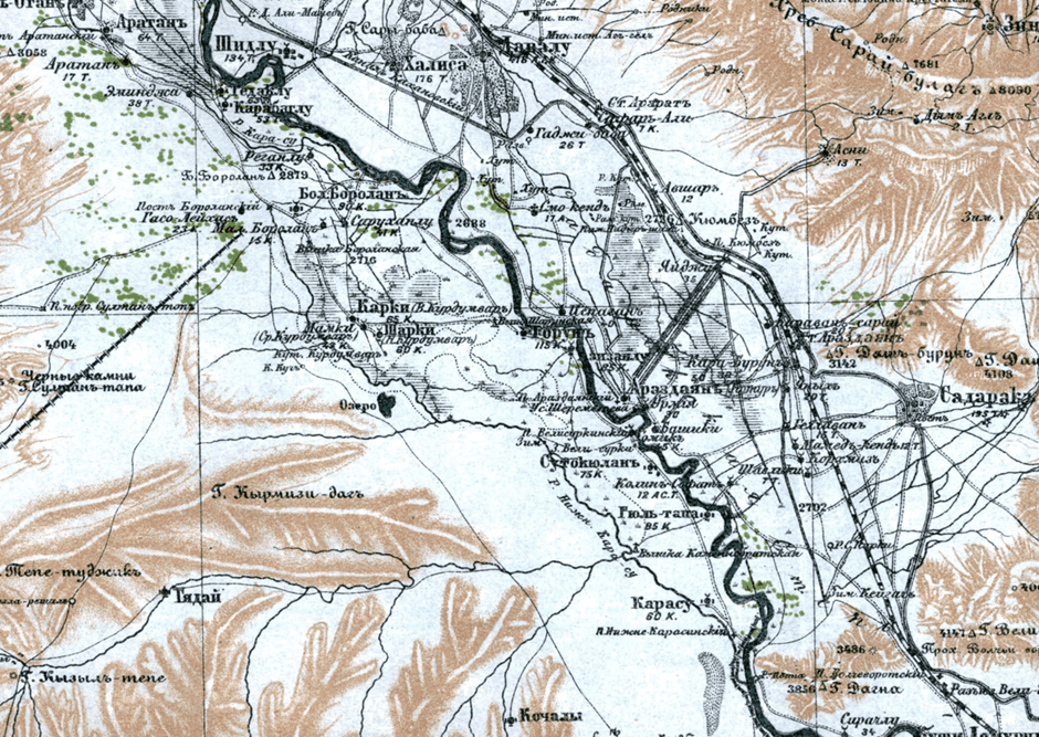
Map 2: The Russian Military Five-Verst Map[ii]
The Armenian-Turkish War and the Formation of Nakhchivan’s Northern Border Through Subsequent Treaties
Between 1918 and 1920, the region in question largely remained outside Armenian control. Reports in the Armenian press from that period frequently mentioned Kurdish group attacks on Armenian villages in the Ararat (Davalu) area. Following the Armenian army’s advances in June-July 1920, the entire left bank of the Aras River in the Nakhchivan section, up to the Shakhtakhti station, came under Armenian control.
Under the Armenian-Russian Agreement of August 10, 1920, Armenian control was recognized over the entire northern section of what is now the Nakhchivan Autonomous Republic, along the line of Shakhtakhti-Khok-Aznabyurt (Znaberd)-Sultanbek (Bartsruni)-Mount Kuk (see Map 3). This situation remained unchanged until November 5, 1920, when Turkish military units stationed in Nakhchivan launched an offensive, capturing the entire area up to the Armenian villages of Smo-Kend, Ararat station, and Saray-Bulag (Urz) heights, located in the southern part of the present-day Ararat Province.
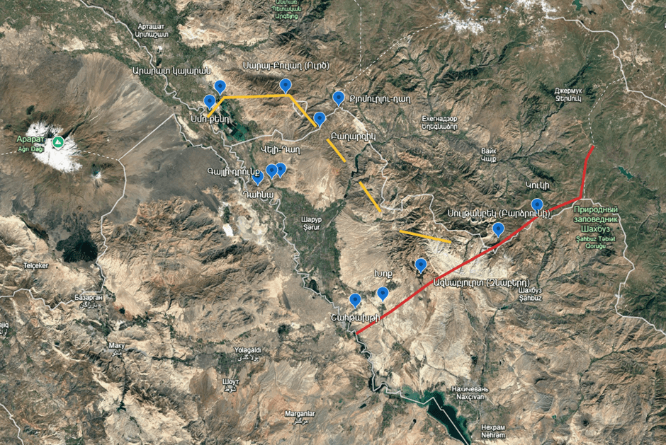
Map 3: The Territory of the Nakhchivan Autonomous Republic Under Armenian Control (Marked in Red) and the Situation at the End of the Armenian-Turkish War (Marked in Yellow)[iii]
The Treaty of Alexandropol, signed on December 2, 1920, formalized Armenia’s defeat in the Armenian-Turkish War. It stated that “the border between Armenia and Turkey begins where the Karasu River (Upper Karasu) flows into the Aras River, at the initial section of the strip connecting Turkey with Nakhchivan.” However, in the Nakhchivan area, the border with the Nakhchivan, Shakhtakhti, and Sharur regions ran further north, along the final front line of the war (south of Ararat station and through the Saray-Bulag [Urz] mountain range). Consequently, this treaty ceded not only Sharur and Sadarak to Turkey but also a small southern section of present-day Armenia’s Ararat Province, including the settlements of Surenavan, Armas, and Yeraskh.
The Treaty of Moscow, signed on March 16, 1921, which transferred Nakhchivan to Azerbaijan, left Nakhchivan’s northern border undefined. Article 3 of the treaty stipulated that a commission composed of Turkish, Azerbaijani, and Armenian representatives would determine the boundary in the triangular area formed by the Dahna-Veli-Dagh-Bagharzik-Kyumurlu-Dagh-Saray-Bulag (Urz)-Ararat station line, the Aras River’s talweg (its deepest flow line), and the mouth of the Karasu River.
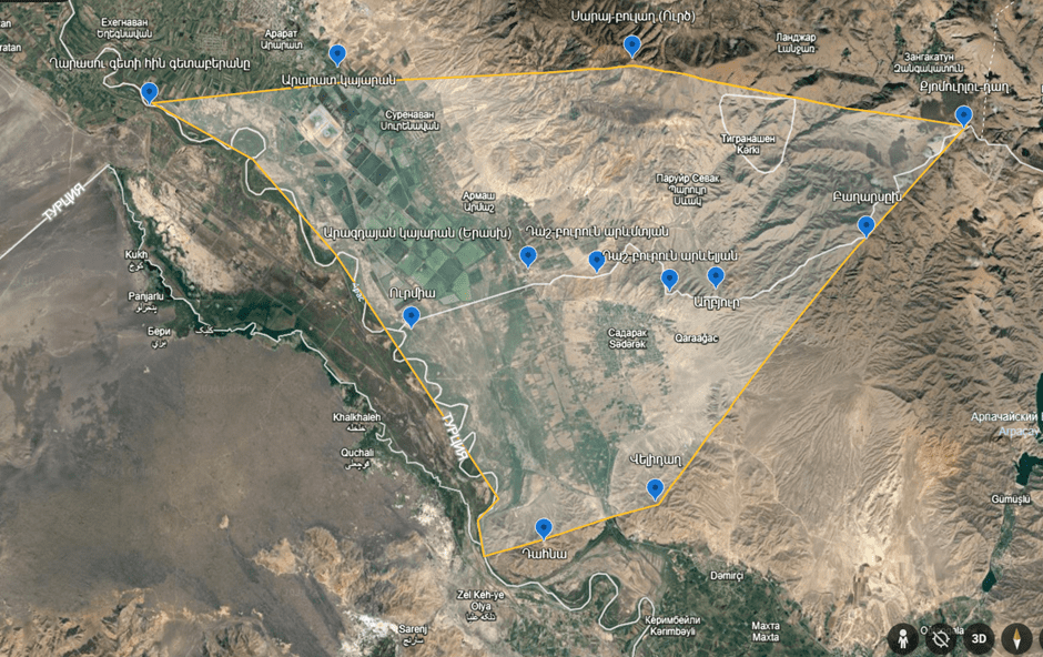
Map 4: The Triangle Mentioned in Article 3 of the March 16, 1921 Moscow Treaty[iv]
The border between Armenia and Nakhchivan described in Appendix III of the Treaty of Kars, signed on October 13, 1921, passes north of the village of Urmia and south of the Arazdayan (Yeraskh) station. It crosses the Jahan-nam-deresi river, south of the source marked on the Russian military map, and follows the watershed line of the Bagarsikh Heights, continuing to the Kyumurlu-Dagh heights. The line described in the Kars Treaty matches the current border and shows that the triangular area described in the Moscow Treaty was nearly divided into two equal halves. This division occurred along the narrow strip on the right bank of the Aras River, which passed to Turkey, preserving a common boundary between Turkey and Nakhchivan of about 17 km.
Additionally, the boundary defined by the Treaty of Alexandropol, which ran further north, was shifted south to the Arazdayan (Yeraskh) station and village. This area, which included several small Armenian settlements, was incorporated into Soviet Armenia. The ethnographic principle also played a role here, as the border passed south of the only Armenian village in the area, Yeraskh.
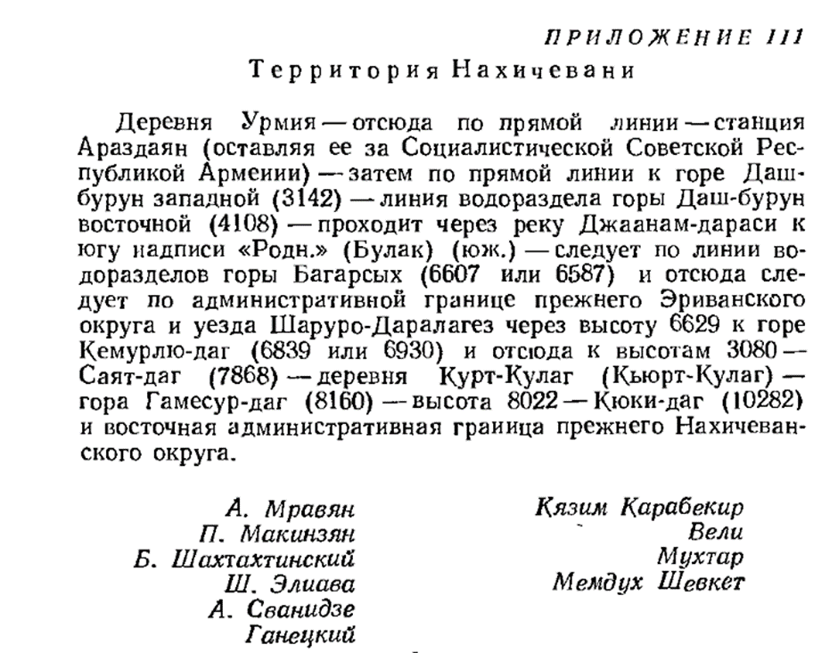
Appendix III of the Treaty of Kars[v]
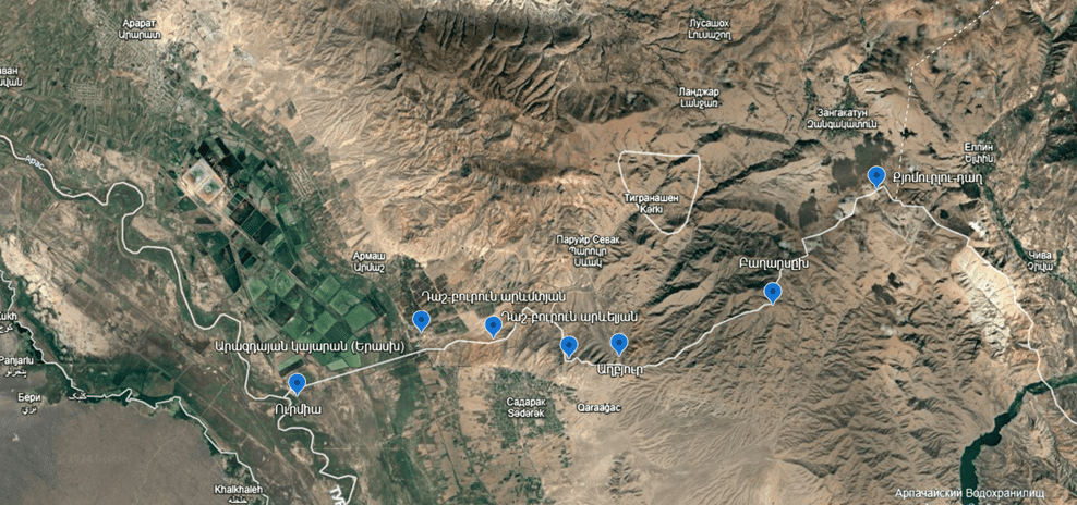
Map 5: The Points Determining the Northern Border of Armenia and Nakhchivan According to Appendix III of the Treaty of Kars[vi]
It should be noted that, in addition to the logical thesis that the narrow strip between the Karasu and Aras rivers was part of the Russian Empire (rather than Persia) during the Tsarist period, following the 1921 Treaty of Kars, and being located on the left bank of the Aras River, it should have been assigned to Turkey. At the end of the first appendix of the Treaty of Kars, there is a direct mention of the common border between Turkey and Azerbaijan, describing the boundary along the talweg of the Aras River: “The Turkish border follows the talweg of the Arpachay River, reaches the Aras River, and then follows the talweg of the Aras River to the village of Urmia, where the border with Armenia ends and the border with Azerbaijan begins, continuing along the talweg of the Aras River to the point where the Karasu River flows into the Aras, marking the end of the border with Azerbaijan.”
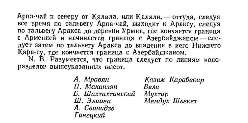
From Appendix I of the 1921 Treaty of Kars[vii]
Thus, the thesis about the absence of a common border between Azerbaijan (Nakhchivan) and Turkey after the 1921 Treaty of Kars is refuted by the text of the treaty itself. The widespread misunderstanding, I believe, is linked to the mistake present in almost all maps published in the Soviet Union in the 1920s (where this boundary is not indicated, see Map 6), which is also an important indicator for exercising caution when referring to maps from that period (this thesis is especially relevant when discussing issues related to Armenian-Azerbaijaniborder demarcation).
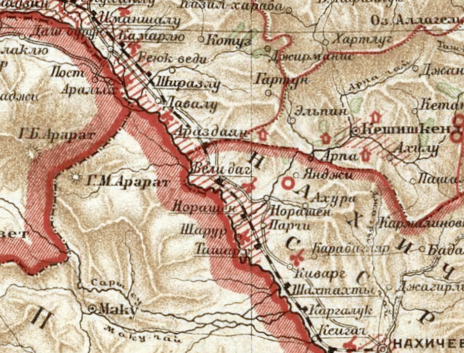
Map 6: The 1926 Map of Soviet Armenia[viii]
On the other hand, the provision in the 1932 Tehran Convention between Turkey and Iran, which formalized territorial changes, including in the area of Little Ararat (where the borders of the Russian, Ottoman, and Persian empires intersected at the summit of Little Ararat until 1918, although most of the slopes belonged to Persia), has led to the conclusion that the section under discussion in the article refers to this area (see Map 7).
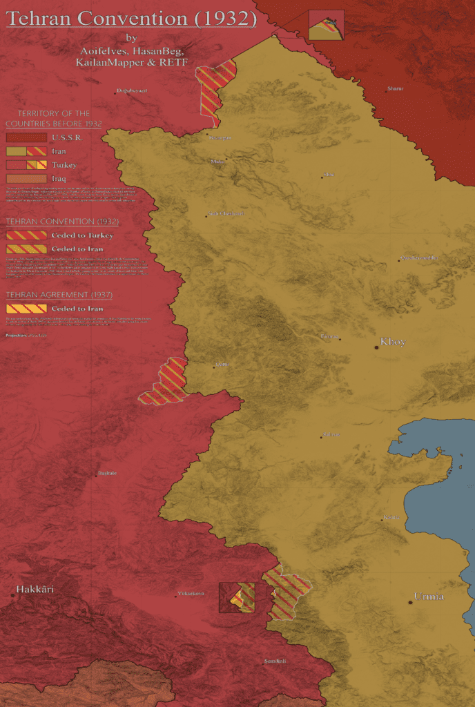
Map 7: The Territorial Exchanges between Turkey and Iran Established by the 1932 Tehran Convention[ix]
Conclusion
The widely held belief that the common border between Turkey and Nakhchivan was formed after territorial exchanges between Turkey and Iran in the 1930s is not accurate and is refuted by the text of the 1921 Treaty of Kars, where the fact of the common border between Turkey and Azerbaijan is directly described and stated.
[i] https://upload.wikimedia.org/wikipedia/commons/c/c6/Ethnographic_map_of_the_Erivan_Governorate-1902.png
[ii] http://www.etomesto.ru/map-atlas_5-verst-kavkaz/
[iii] Author: S. Meliksetyan
[iv] Author: S. Meliksetyan
[v] Documents of Soviet Foreign Policy. Volume IV. Moscow, 1960. p. 429
[vi] Author: S. Meliksetyan
[vii] Documents of Soviet Foreign Policy. Volume IV. Moscow, 1960. p. 428
[viii] The Great Soviet Encyclopedia. Volume III, 1926. pp. 415-416
[ix] https://upload.wikimedia.org/wikipedia/commons/4/47/Tehran_Convention_%281932%29.png
Photo from armenica.org
Author: RCSP associate expert Samvel Meliksetyan
