
Among the most urgent and complex issues in the Armenian-Azerbaijani border demarcation are the solutions related to Armenian (Artsvashen) and Azerbaijani (Upper Voskepar/Yukhari Askipara, Sofulu-Barkhudarlu, Tigranashen/Karki) enclaves. Although until the beginning of 2024, the official statements of the Azerbaijani side often emphasized that the enclaves should also be returned to the Azerbaijani side (and the demand for the return of the Ghazakh region enclaves was included in the preliminary text of the November 9 declaration), after the 2024 “four villages” process, this issue is considered part of the final phase of the border demarcation process.
Discussions in the media and analytical field in Armenia and Azerbaijan regarding the issue of enclaves almost entirely relate to former Azerbaijani enclaves within Armenia, with the main tendency being that these have crucial strategic importance. The speculations and errors related to enclaves that circulate in Armenian and Azerbaijani domains (also in Russian media) are numerous and relate to the origin of enclaves, their territory, population, communications passing through them, and possible solutions to the problem.
The origin of enclaves, former population, territory:
The emergence of enclaves in the Armenian-Azerbaijani border zone is connected with the extremely antagonistic nature of the conflict in 1918-1920 in areas of mixed Armenian-Azerbaijani residence and ethnic border sections. As a result, during the Soviet period, under the conditions of the formation of modern borders, settlements populated by ethnic groups sought to be part of their “native” republic, even if they were separated from the main ethnic area. For this reason, Azerbaijani-populated villages near the border zone but surrounded by Armenian villages sought to be part of Soviet Azerbaijan, while Armenian villages sought to be part of Armenia. For this reason, the border in Armenian-Azerbaijani ethnically mixed zones deviated from natural geographical objects and became complex, giving rise to numerous enclaves (the Nagorno-Karabakh Autonomous Region was also an enclave), exclaves (Nakhichevan), and pene-enclaves[i].
In the Tavush enclaves section, especially the Muslim population of the Voskepar valley villages in July-August 1920 was “used” by the Bolsheviks to justify military intervention against the Republic of Armenia. In that section, according to the Armenian-Russian treaty of August 10, 1920, the parties remained in the positions they had occupied as of July 31. According to that treaty, under Armenian control in that region were the villages of Upper and Lower Voskepar, Mazam, Kushchi Ayrum, Baghanis Ayrum (the Upper Voskepar enclave and the Lower Voskepar pene-enclave entirely). However, Red Army units already violated the ceasefire regime on August 11, and, using the support of Muslim residents of these villages, went on the offensive, also capturing several Armenian villages. Clashes between Armenian and Red Army units in that section continued with varying success until the end of September 1920, in connection with which the Armenian government sent protest notes to the Bolsheviks[ii]. Based on other similar practices of the Bolsheviks, it can be argued that the use of enclave and other small Muslim villages within Armenian villages as a pretext for military operations against the Republic of Armenia was most likely the main reason why later, during the early Soviet period border demarcation processes, they were transferred to Soviet Azerbaijan, creating the complex geometry of the Armenian-Azerbaijani border in the form of enclaves, pene-enclaves, and so-called “tails.”
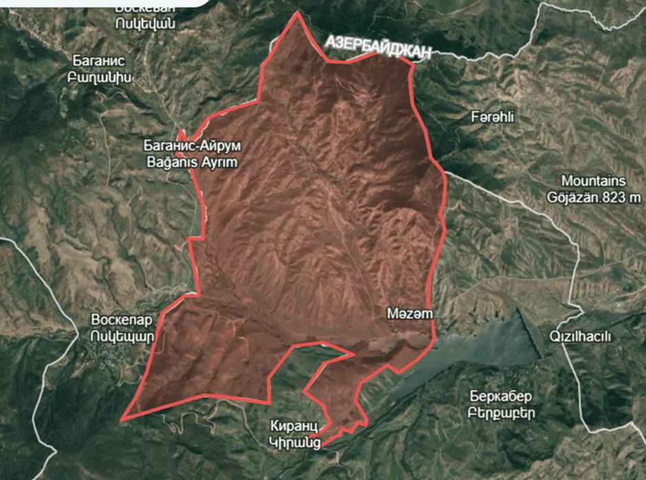
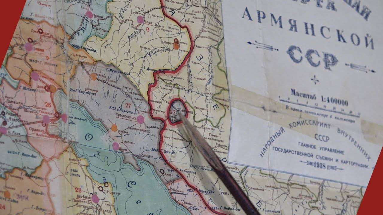
Map 1. Azerbaijan’s Askipara pene-enclave according to Soviet administrative borders.
Although there is a widespread opinion in Armenian media that the population of Azerbaijani enclave settlements is the result of Soviet-era resettlement policies, all these villages (Upper Voskepar (Azer. – Yukhari Askipara), Sofulu, Barkhudarlu, Karki) existed at least from the second half of the 19th century and are recorded in Tsarist statistical sources, though they were small villages. For example, according to 1886 data, the Muslim-populated Sofulu village had 103 inhabitants, Barkhudarlu village had 69, and Upper Voskepar had 202[iii]. Artsvashen (Kushchi, Bashgyugh, Bashkend) was a much larger village and in 1897 had 1,847 inhabitants.
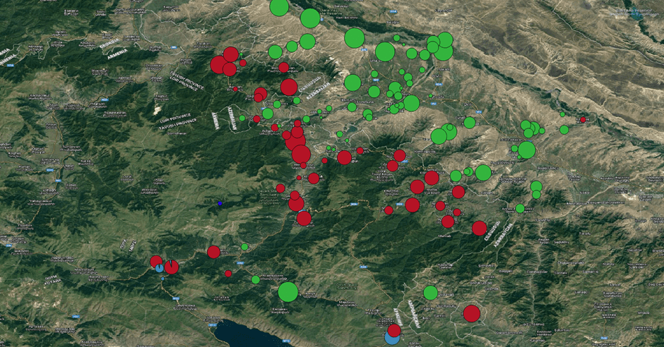
Map 2. Armenian (red) and Muslim (green) villages in the Tavush section in 1886 and modern borders (the size of the circles reflects the size of the village)
In the early Soviet period (1920s-1930s), as a result of the work of border commissions, different solutions were adopted several times regarding these villages, although initially a direct land connection with the “mother” country was assumed. For example, there was a direct land connection between the Sofulu-Barkhudarlu villages and the main part of Azerbaijan, as in the 1922 description of the Armenian-Azerbaijani border, the border passes west of these villages[iv]. The same applies to the large Armenian village of Artsvashen (Bashgyugh). From the early 1930s, the enclave format was adopted for these villages. The history of the enclaving of Karki (Tigranashen) is more obscure, although it is known that by the 1920s it was already effectively part of Nakhijevan.
The population of these enclaves during the Soviet period, except for Artsvashen, was small. According to the 2009 Azerbaijani census, the relocated population of the three enclave villages of the Ghazakh region was as follows: Upper Voskepar – 637, Sofulu – 182, Barkhudarlu – 421, and New Karki of Nakhijevan (entirely relocated from Karki village) – 380, totaling 1,620 inhabitants. (The residents of these villages who settled in various settlements of Azerbaijan in the 1990s continue to remain officially registered as residents of these former villages). Since in 1989 the population of Upper Voskepar was 500 people, the natural growth rate for the period 1989-2009 (from 500 to 637) can be calculated at about 1.27 times, considering it as the median and reconstructing the approximate population of these Azerbaijani villages in 1989 – 1,270-1,300 inhabitants. In Artsvashen in 1979, there were 2,771 Armenian inhabitants – at least twice as many as in all Azerbaijani enclave villages within the territory of Armenia combined. It should be noted that in Azerbaijani sources, Wikipedia, as well as Russian and international media publications, the population of Azerbaijani enclave villages is significantly inflated. For example, for the Sofulu-Barkhudarlu enclave, 2,000 inhabitants are mentioned[v].
The same issue persists with the territories of the enclaves. For example, for Upper Voskepar, 37 km² is mentioned (almost the size of Artsvashen), for Sofulu-Barkhudarlu – 22 km², for Karki (Tigranashen) – 19 km², meaning the total area of Azerbaijani enclaves amounts to 78 km², whereas even a visual comparison with Artsvashen on a map of the same scale shows that the Azerbaijani enclaves are incomparably smaller.
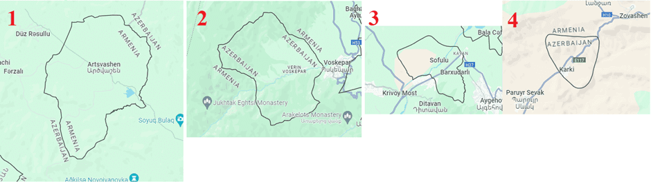
Map 2. Visible (visual) sizes of enclaves on a map of the same scale.
1. Artsvashen
2. Upper Voskepar
3. Sofulu-Barkhudarly
4. Karki
According to my calculations[vi], the area of Upper Voskepar is 26 km², Sofulu-Barkhudarlu is 9.87 km², and Tigranashen (Karki) is 8.13 km². The area of Artsvashen is 38.2 km². It should be noted that according to the maps of the Soviet Army General Staff, two Azerbaijani micro-enclaves (with a total area of 0.2 km²) are also indicated east of Paravakar village in Tavush province, but that entire section (more than 10 km² of RA territory) is occupied by Azerbaijan. Thus, the total sum of all Azerbaijani enclave areas (44.2 km²) is 6 km² larger than the area of Artsvashen (38.2 km²).
Azerbaijani enclaves came under Armenian control in the following order: Karki (Tigranashen) on January 19, 1990, Sofulu-Barkhudarlu on April 27, 1992, Upper Voskepar on June 8, 1992 (after four days of persistent battles). The Azerbaijani Armed Forces captured Artsvashen on August 8, 1992.
Tigranashen is the only settlement in the territory of former enclaves that has a permanent population (mainly Armenian refugees from Azerbaijan). In all other enclaves, the majority of the housing stock has been almost completely destroyed, and traces of former villages are difficult to discern.
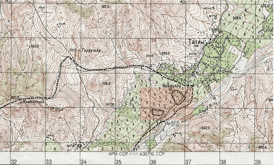
Map 3. Two Azerbaijani micro-enclaves located in the section of Paravakar village of the Republic of Armenia, which are completely occupied by Azerbaijan (Soviet General Staff map, scale 1:500,000, 1977).
Problems and infrastructure related to enclaves:
During the Soviet period, inter-republican borders were administrative in nature; they could be freely crossed, certain economic activities could be conducted in the territory of a neighboring republic, communications could be built, pastures, natural resources, and water resources could be used, etc. The asphalt road connecting Artsvashen with the Armenian SSR was built from the republican budget of the Armenian SSR, and communication between the enclave and Soviet Armenia was free. The same applied to Azerbaijani enclaves within Soviet Armenia. Moreover, these enclaves could also be crossed by internal infrastructure of Soviet Armenia—roads, economic facilities, and even settlements (completely or partially, as in the case of the Sofulu-Barkhudarlu enclave, which also contained the Armenian settlement of Kayan). Under conditions of a state border, however, the presence of an enclave is viewed as a circumstance that adds additional complexity to interstate relations. Although entering the territory of an enclave may have facilitated regulations, such solutions also imply a high level of trust and relations between states. Otherwise, as in Central Asia, for example, access to enclaves is carried out through checkpoint regimes and creates numerous complications both for the population and in interstate relations (including armed clashes).
International precedents also imply limited military presence in the territory of enclaves, which may consist of border guard and police forces. For this reason, for example, in 1939, after Franco’s victory in the Spanish Civil War, a republican administration was maintained in the Spanish enclave of Llívia located within France, since Spanish soldiers needed special permission to pass through French territory. Another serious problem with enclaves is the infrastructure entering the enclave (water supply, gas pipelines, electricity, communication), as well as various services (postal, medical, etc.), problems with which can paralyze regular life in the territories of enclaves. For example, some of the enclaves of India and Bangladesh were deprived of electricity because the parties had no agreements regarding infrastructure.
Such complications related to enclaves are the main reason for their exchange (e.g., the exchange of more than 150 enclaves between India and Bangladesh). This solution is also considered optimal in an OSCE study[vii], taking as an example the transfer of the Lithuanian enclave of Pagiriai to Belarus and the latter’s compensation with an equivalent area. Following the same logic, as a result of the Russian-Azerbaijani border demarcation (2010), two village-enclaves of Dagestan (RF) in the territory of Azerbaijan’s Khachmaz region—Khrakh-Uba and Uryan-Uba, whose residents were citizens of the Russian Federation—were handed over to Azerbaijan. After prolonged protests, the residents of Khrakh-Uba were forced to relocate to the Russian Federation.
The second part of the article is here.
Photo: CivilNet
Samvel Meliksetyan
[i] Pene-enclave – territory of one state that has a common land connection with that state. However, the road leading to that territory passes through the territory of another state (or other administrative-political unit).
[ii] Hovannisian, Richard G. The Republic of Armenia: Between Crescent and Sickle: Partition and Sovietization. 1996. Vol. 4. P. 103.
[iii] Свод статистических данных о населении Закавказского края, извлеченных из посемейных списков 1886 г. Тифлис, 1893. // Казахский уезд.
[iv] Bulletin of the Archives of Armenia, 2017, № 125, p. 74
[v] https://www.kommersant.ru/doc/2674108
[vi] From Google Earth’s standard area measuring tools, where the error interval is a few percent.
[vii] https://www.osce.org/ru/secretariat/363471
